
Project: Black Pig’s Dyke Research Project, Co. Monaghan.
Location: Corrinary, Co. Monaghan.
Year: 2014
Client: Kilkenny Archaeology
Funding: Monaghan County Council
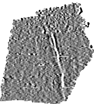
Electromagnetic Data showing the ‘Black Pig’s Dyke’
Aim: The Black Pig’s Dyke constitutes a series of earthwork fortifications located along the border of Northeast Connacht, Southwest Ulster and a small portion of Northwest Leinster throughout the counties of Cavan, Fermanagh, Leitrim, Longford, Monaghan and Roscommon with some possible links to earthworks in Counties Armagh, Donegal and Down. The earthworks comprise a series of banks and ditches with the banks being on average 9 metres wide and the ditches being on average 6 metres in depth, and having at one point contained a substantial palisade structure.The earthworks are considered to have an Iron Age provenance and were theorised by antiquarians to comprise an ancient boundary wall demarking the area of Ulster from the south, in particular as a defence against cattle raids.
Earthsound were commissioned by Kilkenny Archaeology as part of their involvement in the larger Black Pig’s Dyke Research Project, to investigate a portion of the Dyke located within the townland of Corrinary in County Monaghan, near the Cavan border. An Electromagnetic survey was executed across the site and two ditches (a substantial one to the north and a smaller one to the south) were discovered along with evidence for a possible burnt palisade.
Outcome: The geophysical surveys undertaken for this project have successfully identified the exact location and composition of the Black Pig’s Dyke within the survey area. Confirmation has been gained for the presence of two ditches, one on the internal (southern) edge of the dyke and a more extensive one on the external (northern) edge. Additional features included a possible palisade and ditch.